Pages

Monday, September 2, 2013

Day 24 - Finished with one last wrinkle!


The plan for today was to start early, spend an hour getting to the start of our last challenge set - The Twisted Sisters - and finish them by lunch time, then make a dent in our travel to return home. Well, mother nature apparently wasn't tuned in to our plans...

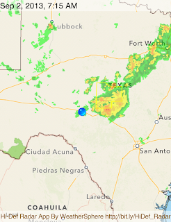
As I usually do first thing when I get up in the morning is to check my weather app on my Ipod. I was shocked to see a rather large "blob" of thunderstorms headed directly for us from the northeast! The forcast had called for "scattered showers" which usually means "later in the day from the heating of the sun" not active storms at dawn! Larry and I checked out a few sources and we agreed, based on what we were seeing that the storms appeared to be moving pretty fast and that if we delayed an hour or so they would pass by and we could go on with our plan after that.

The map on the left shows our overnight location with the blue pin and the weather front not moving as it would appear normally (northwest to southeast), but rather like a spear with a big head aimed right at us! We actually saw lightning while we were loading the bikes and when we got back from the in-house breakfast, it had already started to sprinkle where we were. So, we waited, but as the sun came up the storm seemed to slow down such that had we left when we were ready we might have made it out in front of it, but now we were committed to waiting it out. Well, long story short, we ended waiting until almost 11:00 AM before we could leave, and even then we were geared up for rain AND we modified our route to run out further east around the "back" of the head of the storm. 

To make things even more exciting, there was also a weather advisory for flash flood warning that included one of the roads we were preparing to take! Well, we rode down I-10 to Junction TX and got off the interstate there, fueled up and then called to local sherriff's department to check if our intended route down TX-377 has any reported closures. They said no so we opted to try it. Now, there were at least 5 signs along the way warning of potential flooding over the next 30 miles, and we did go over two bridges where the water was very near the road surface, but ultimately, we made it down to near Rocksprings where we would make out entry onto the first of the three twisted sisters roads - FM-335.

The "Twisted Sisters" are three FM "Farm to Market" roads in Texas Hill Country. FM-335, FM-336, and FM-337. The tree roads together total approximately 125 miles of roller-coaster like riding, along with some nice views of very small canyons, and lots of streams, arroyos (dried up river beds), and a few larger rivers. There are NUMEROUS places where the water can and sometimes does come up over the road, many indicated with "flood gauges" that are essentially long yardsticks that stick up alongside the road to indicate how high over the road the water may be at such an occasion. Given the weather and the severity of the published flash flood warnings, we were extremely lucky to NOT encounter any significant water over the roadways. We did see the occasional puddle or wet road surface, both of which commanded our respect. The other bonus with the weather was that it remained cloudy for most of the day which helped keep the temps from climbing too far into the 90's!

Our final Day's route


Elevation Profile as we rode up and down the canyon walls!

Ominous skies behind us when we stopped in Junction TX for fuel


Larry at the 335 start
Larry at the Camp Wood City limit (end of 335)


Bill at the Frio Canyon Motorcycle Stop in Leakey
We stopped for lunch at the Bent Rim Grill - Bill posed above (with his water hose in mouth)

Larry at the start of 336
Larry at 41 (end of 336)
Larry at the 337 sign just as we leave Leakey
Larry at the Medina sign (Official end of 337 and our Best 15 Challenge Ride)

Most of these pix show Larry because I took them of him. Rest assured a similar set of ME at each of these spots exists! 


Sunday, September 1, 2013

Day 23 - Setting up for Finish!

Today was our last transit day. We left Las Cruces, NM and rode entirely on the I-10 interstate to get to Sonora, TX. Nothing exciting, just grinding away the miles to set up for our last day tomorrow when we ride our final Challenge roads - 3 Texas back roads dubbed the "Twisted Sisters".

Today's route file:


Today's elevation profile:

As you can see from the above, we ran mostly "downhill" to lower elevations than we've been in over the last several days. We also crossed back into the Central Time Zone so we are now just one hour behind "home time".

We did have to run through El Paso, which can be a real pain if its normal traffic, but since it was early on a Sunday morning, it was pretty much a breeze. The temps were warm enough to start that we didn't need liners in our jackets, and by noon the temps had warmed into the upper 70's.

We did have to make a stop at the border patrol checkpoint and wait our turn in line to be asked if we were US Citizens before being allowed on. It probably held us up for 5 minutes, which doesn't sound like much unless you are sitting in an ambient air temp at 95+ degrees. I don't see how that can be justified, but it is what it is and there's nothing I can do to change it right now.

After our lunch in Ft. Stockton TX the temps were 93 and climbing. It leveled off in the upper 90's but I did see a brief flash to 100! We got in at 3:30 local time and I got a really appreciated dip in the outdoor pool.

So now we are making our final plans for the ride home. We both are expecting to make it home by Thursday evening, or Friday at the latest.

Today's stats: 427.1 miles in 5:57 moving time, 7:07 elapsed time.


Saturday, August 31, 2013

Day 22 - US191 and a whole lot more!

So, today was kind of an odd day. We were starting out in Springerville, AZ which was the northern point of our Top 15 Road assignment for today, but because Arizona doesn't observe daylight savings time, we were an hour "behind". The good part of that was that when we started the sun was a bit higher in the sky, but it also meant that later in the day when we crossed back into New Mexico we would lose an hour again.


So we started out on US-191 for a planned 121 mile trip to Clifton AZ which the GPS said should take us 4 Hrs 22 minutes. That seemed kinda long to us, but we just went ahead and ran it. The road travels through the San Francisco Mountain range in the Sitgreaves National Forest. It would take us up and over one 8,550 ft mountain pass and then wind us up and around, but not over any other passes, two other mountains - Rose Peak and Mitchell Peak. Well, this road just twists and turns and pitches up and down and it almost never ends! Most of it was posted 55 MPH more or less, which was fine even for the turns, but the later sections the posted speed limit was 30 in many places and even 15 to 20 in some, due to the tightness of the turns. That's why "Jill" (our affectionate name for the GPS voice) said it would take so long. We didn't stick so closely to the posted limits  and managed to complete it in 3:12 - but it was a HARD 3:12! There is just so much concentration and physical exercise required to run that many miles on such a continuously twisty road and also have to watch out for deer, cattle, people (hikers and cyclists), other traffic, sand and gravel in the corners... The list just goes on. So by the time we got to the copper mine near the end, I was ready for some "easier" roads. Well with Larry doing the routing I should have known better!


After we finished 191, we turned eastward on Highway 78 which would cover some 35 miles or so across the state border into New Mexico. Well this road was nearly as twisty as 191! We then turned south onto US-180 and did get a bit of a break there for a while with straighter road, but even that would take us up over an unnamed summit pass of 6,230 ft just as we pulled into Silver City NM. We stopped there briefly for lunch and then headed out on NM-152 which would take us up over Emory Pass (8,228 ft) in the Mimbres mountains, also part of the Gila National Forest. Here again, another road well worthy of "Top 15" status. But, to make it even more exciting, there were more than several places on this road where previous heavy rains had washed out sand across the road making for one more hazard to be ever vigilant of. By the time we got to I-25 we had covered 300 miles of extremely challenging roads and I was ready for a break. We had only 60 miles to make Las Cruces where we had a hotel reservation, but even that would be work since the temperature had climbed steadily all day from the 54 degrees on the early sections of US-191 to now reaching 100 degrees on I-25! Needless to say, when we got to the hotel we were two hot and weary riders, but ever so happy to have had the thrill of riding these wonderful roads!

Stats: 351.9 miles in 6:54 running time, 8:06 elapsed time


Friday, August 30, 2013

Day 21 -The Million Dollar Highway

We start out this morning in Montrose, CO at the start of our required segment named "The Million Dollar Highway". It consists of US-550 from Montrose, CO down through Ouray and Silverton and ending in Durango, CO. It is also part of the San Juan Skyway Scenic Byway.

Todays route:


The elevation profile tells the real tale:


The ride from Montrose down through to Ouray was nothing too special, save the copious warnings for deer crossings and something called a "wildlife detection area".
You can see that we started out in Montrose at 6000 ft elevation, but then start a dramatic climb up to over 11,000 ft, and then drop and crest two more passes before descending back down to the 5000 to 6000 ft range. What those three peaks are the three passes that make this such a great motorcycle ride. For more information about this road see wikipedia.org/wiki/U.S._Route_550

The real fun began coming out of Ouray. Here the road begins a very steep ascent with numerous switchbacks and mostly no guardrails up to the Red Mountain Pass (11,018 ft). Then there is an almost 2000 fy descent and we climb once again up to Molas Pass (10,970 ft), and then one more smaller drop before climbing to the third and final Coal Bank Pass (10,640 ft) and then a dramatic 3500 steep descent. This all would have been much more exciting had we not been behind a large group of Harley riders who were very careful to strictly observe all speed signs, especially the ones in the turns. They were too big a group to pass so we just sat back and followed and tried to enjoy the views. I didn't get many photos as I was running the GoPro in video mode (the upload of only one segment is underway but scheduled to take over 3 hours).


Once we got to Durango we gasses up and headed south for a long ride down through northwestern New Mexico. The ride wasn't anything too special, though we did see a LOT or bikes headed in the opposite direction. Eventually we arrived at I-40 where we were supposed to head west, cross into Arizona, and than take US-191 south from there. As we approached I-40 however, the storm clouds were gathering and just as we got to the ramps we were seeing lightning so we stopped and re-considered our plans. A driver who just came off the road told us there was heavy hail. We decided to detour eastbound on I-40 out to Grants NM and then take a two-laner (NM-117) which would take us alongside the El Malpais National Monument. There we did also run into some rain, but never hard or long enough to force us into a gear change. We did pass an accident scene where another motorcyclist had apparently left the road. Eventually we ran out from the rain and arrived in Springerville, AZ about 30 minutes later and much drier than we would otherwise have!

Stats for the day: 437.5 miles in 7:50 moving time, 10:15 elapsed time.


Thursday, August 29, 2013

Day 20 - Transit day - with bonuses!

Today was supposed to be a "transit day". That is, we had no scheduled Top 15 roads to run, only get from the end of one to the beginning of the next. Well, let me tell you, we ran the better part of the day on roads that were certainly worthy of Top 15 status, and even then some! The short story is we had incredible scenic views, huge elevation changes, twisty roads, dirt road, rain and even hail!

Day 20 Route
We started out the day from our hotel in Caineville, UT. That is on UT-24, just east of the Capitol Reef National Park. Even though it is outside of the park, that UT-24 continues to be a scenic and twisty route east. The only issue here was the early time of the morning, we had bright sun directly in our eyes which made it hard to see the roadway so we did have to run carefully. Despite that it was still fun to ride and scenic in its own right.

Then we turned southerly on UT-95 which, in my opinion, is every bit a candidate for a Top 15 road as any we have run to date!

Views from early section of UT-95

Views from early section of UT-95
 Later in the morning, as the sun has risen higher we enter a section of UT-95 that passes through the Lake Powell Glen Canyon Recreational Area. This section winds through some incredible red rock canyons and alongside some of the rivers that feed Lake Powell. We stopped alongside the road to shed a layer of clothes as the day warmed up.

View back along UT-95 where we stopped to remove a layer of gear
We twisted and turned a few more miles through red rock canyons before we came to a scenic vista where we pulled off for some photos.

Looking south down the upper most reach of Lake Powell - note it's Very Low 

Looking westward up an upper arm of Lake Powell - nota again how low the water is


Look closely near the upper right of the photo - there's a boat launch ramp that's completely out of the water line - that's how low the lake is here!

After taking the above photos, we continued to wind down through this canyon and around to cross a bridge (seen in on of the above photos) and continued down UT-95 until we detoured off south of the Natural Bridges National Monument in order to traverse a special stretch of road called the Moki Dugway.

In order to help you appreciate the riding consider the elevation profile below. For the sections I described above, look at the elevation changes for the first 112 miles in the chart below:


You can see how we started out at 4600 ft, did a short climb to a tad over 5000, then as we descended into Glen Canyon, dropped to a little below 4000 ft, then climbed back up steeply to near 7000 ft. That's where we turned off UT-95 to head for the Moki Dugway. Hint: Google "Moki Dugway" for some interesting background information on this unique feature.

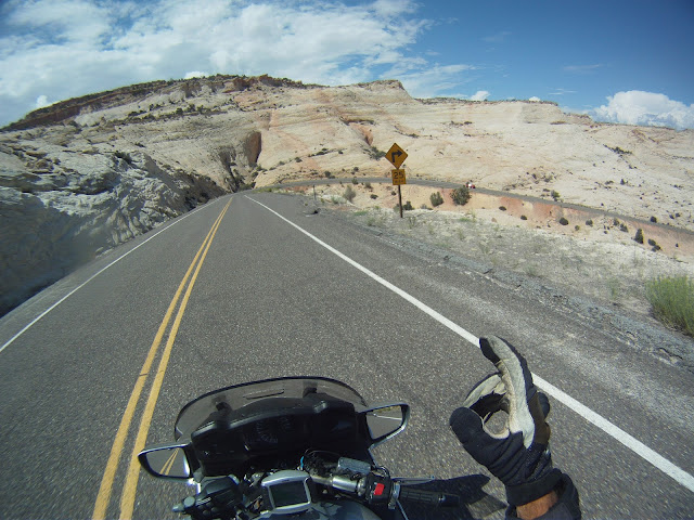
We turned off UT-95 onto UT-261 to head to the Moki Dugway. Essentially, this would take us to the top edge of a huge plateau and then on a dirt road (at first) we wound steeply down the face of this plateau with sharp unpaved switchbacks until we exit out onto the floor of Monument Valley dropping some 1000 ft in just 2.4 miles, and then continues to drop (on now paved road) another 1000 ft before another steep climb and descent from the valley floor until we finally climb back out of the valley on UT-191 from Bluff, UT to Monticello,UT.

Stopped on the Moki Dugway

View of the remaining descent on the Moki Dugway

View back at the Plateau we came down from on the Moki Dugway!
Once we got to Monticello, UT we decided to stop for fuel just as we turned eastward onto US-491 which would take us across the border into Colorado. This was probably the only "boring" road we have been on in several days. It was fairly straight, and although it encompassed undulating hills, it had a lot of construction and re-paving operations in progress. Still, we only spent a little under an hour to run the 50 miles 'till we turned north onto CO-184 which would take us up into and through the San Juan Mountain range. In the process, we would cross our highest pass to date, the Lizard Head pass (10,222 ft). It was a sweet ride up towards the pass but we did spot storm clouds building and knew we might run into some rain Eventually Larry's weather alert said there was a thunderstorm ahead, not too many seconds before we saw a large flash of lightning off in the distance. We decided to stop and gear up for rain and then continued on. Well, we hit rain less than 1/4 mile from where we geared up! Good thing too because in addition to the rain the temps dropped from the high 70s into the mid 50s in very short order. The rain only lasted a few miles and we crested the pass on nearly dry roads and then started a descent that would take us down into Keystone, CO. When we got to Keystone, there was a major road project going on that really messed up the traffic. So much so that we decided to drop of the detour we planned to make to get up to Telluride, and instead opted to just continue on our descent now on CO-145 to Placerville. By this time the temps had warmed back up into the 70s and we were getting too warm in the rain gear and considered shedding it, but decided not to because we knew there were still thunderstorms in the area. Another excellent call, as just a few miles down the road (now on CO-62), it began to rain again - HARD. Then, suddenly amidst the heavy rain, pieces of hail began mixing in and bouncing off our bikes, bodies and helmets! Thankfully, the hail only lasted about 30 seconds and then the rain began to slowly trail off too. We would run into one more bout of rain as we turned off 62 and onto US-550 in Ridgeway. After that it cleared and warmed and it was just a test to see if we could stand the heat in the rain gear until we reached the hotel in Montrose - which we did!
View of the construction and scenery as we entered Keystone, CO Note the clouds over the mountains!

So, that caps off another spectacular day of riding. Stay tuned for more!

Stats for the day: 394 miles in 7:13 moving time, 8:53 elapsed time.


Wednesday, August 28, 2013

Day 19 - Utah

Today's ride wasn't quite as eventful as yesterday, but it was still another spectacular ride with equally spectacular scenery to boot.

We were on the road at 7:15 AM and it it wasn't long before we were crossing passes once again, starting with Connors Pass (7,722 ft) in the Schell Creek Range, followed shortly by the Sacramento Pass (7.154 ft) in the Snake Range ( in between the Humboldt-Toiyabe National Forest and the Great Basin National Parks. Not long after that we crossed into Utah and changed back to the Mountain Time Zone.Next we took UT-21, a lonely little 2 lane road where we saw a sign - "Next Services 75 Miles".After another 50 miles we crossed an unnamed summit at 7200 ft, our third for the day. We then got onto I-15 for a short jog south and than back onto another 2 laner - UT-20, and crossed yet another unnamed pass of 7910 ft in the Pahvant Range where we then caught US-89 south to the town of Panguitch, and the start of our Top 15 road for today - UT-12.


UT-12 - What a GEM of a road. I can certainly see why it's on this select list as well it deserves to be. It snakes some 123 miles through and around the Dixie National Forest. It starts out through Red Canyon and then crests another unnamed summit of 7,619 ft. It then passes the entrance to Bryce Canyon. From there is winds around and crests another 7400 ft summit all the while providing breathtaking scenes of natural beauty that I just don't have words to describe. Finally we climbed up the 9200 ft summit just past Boulder UT and then weaved our way back down the other site to end up in Torrey UT and the finish of this segment.


We dined in Torrey as our hotel was 30 miles down UT-24 with no restaurants nearby. After a Bison Burger we stopped for fuel and oh, what a surprise - UT-24 winds it's way through the Capitol Reef National Park before we reach our hotel for the night in Caineville UT.


Today's Stats: 385.1 miles in 6:43 moving time, 8:43 Elapsed time.

Added GPS Track for the day:


Day 18 - Up, down and everything!

We had SO MUCH going on today, I'll probably not be able to get it all down tonight as the Internet connection isn't too great, but I'll get down what I can and come back to fill in the rest later (another day).

The short story is we had smoke, mountain ranges, mountain passes, rain, over sized vehicle roadblocks, winds gusting to 40+ MPH and temps from 54 to 88! It was a real challenging riding day.


Our day dawned somewhat as usual, except that when we went to load the bikes, there was a distinct pall of smoke filling the air. You could see it and smell it. It, of course, was smoke from the nearby Rim Fire as has been making the news all week. Our hotel was loaded with fire fighters, all of which were gone by the time we went out to load at 6:30 AM!

We were on the road at 7:17 AM and headed out to pick up CA-4 which would take us through the Sierra Nevada Mtn Range, and the first 2 of several mountain passes for the day. As we began our climb up the mountains the smoke thickened and not only affected visibility, but was causing physical symptoms like burning eyes, headaches, and sore throats. We really were hoping it would thin out before too long. It did vary some but it hung thick enough to be troublesome all the way through to lunch time at Fallon, NV some 53 miles from our days start!

Smoky air as we headed out towards CA-4

The first of MANY summit passes this day
Mosquito Lake - at Pacific Grade Summit
Smoke fills the air looking towards the east (from Pacific Grade Summit)
Looking Southwest from Pacific Grade (towards where the Rim Fire is burning)

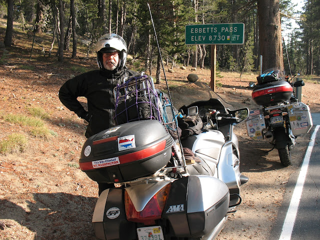
Ebbetts Pass - in the Sierra Nevada Range
Still smoky on US-50 before Fallon, NV


Before I get much further, let's look at some of the details or our trip today -

Route taken today from Sonora CA to Ely, NV
I mentioned going over mountains, so here is the elevation profile of our days trip:
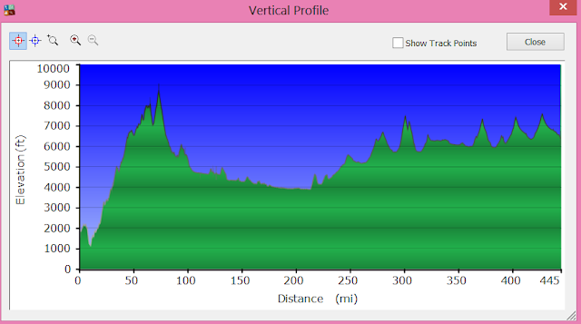
You can see that we spent almost all of the day above 4000 feet elevation and went up and down 1000 feet several times

Mountain Summary:

We crossed over five mountain ranges, which included nine named mountain
passes, all of which were over 6000 ft elevation!

Sierra Nevada Mountain Range -

CA-4 Pacific Grade Summit - 8050 ft
    Ebbetts Pass - 8732 ft

Desatoya Mountain Range -

US-50 New Pass Summit - 6340 ft

Toiyabe Mountains -

US-50 Austin Summit - 7884 ft
     Hickison Summit - 6594 ft

Diamond Mountains -

US-50 Pinto Summit - 7382 ft

White Pine Mountains -

US-50 Pancake Summit - 6521 ft
     Little Antelope Summit - 7438 ft
     Robinson Summit - 7539 ft

We fueled up in Carson City UT, just prior to starting on our Challenge route - US-50 from Carson City UT to Ely NV. Smoke was still an issue, but we were ever hopeful. We also planned to stop in Fallon, NV for lunch because the timing was right and it was the last real city we'd see before getting to Ely, NV which was some 320 miles from Carson City. When we rolled into Fallon we found a Burger King for lunch and by the time we got back out on the road we were seeing some real improvement in the smoke situation - and none too soon for us. Larry was complaining about a headache and burning eyes, and I had a sore throat and burning eyes.

Finally starting to clear as we get away from Fallon, NV - over 55 miles from our start today!
We made some nice time across US-50 from Fallon to Eureka, but Just before we reached Euraka we had to stop and put on our rain gear. We could see dark clouds out ahead and Larry's GPS radar showed us heading right through a thunderstorm. Luckily, as Murphy's Law of motorcycling goes, though we did hit some rain it was only moderate and only for about 15 minutes or so. Still we were glad to have put on the gear because the temps plummeted by some 20 degrees as a result of the rain. Even after it stopped we kept the gear on as we headed into Eureka and then we found our next challenge - As we were coming out of Eureka we came up fast on a lot of flashing lights and stopped cars. Turns out there was a caravan of three semis hauling three oversize loads of those really huge mining dump trucks. They had at least 4 pilot vehicles in attendance as well as a Nevada Highway patrol car making sure nobody tried to pass them as they crept (literally 10 MPH or LESS) up the steep grade of what would be the Pinto Summit (Elev. 7382 ft). We really couldn't believe that they would block all traffic for as long as it was going to take, but they held us up for some 12 minutes as they traveled just 2 miles up to the pass where, thankfully, they bunched up and pulled over in a turnout and the Highway Patrol waved the waiting vehicles around! We were ever so grateful as it had started to really warm up and we were starting to sweat in our rain gear. So we're now past the rain and the traffic jam and looking for some place to pull over and get out of the rain gear. That's when we noticed two more Nevada Highway Patrol cars were forcing all oncoming traffic off to the side of the road in anticipation of the oversize loads coming through. Man those folks were goaing to have a LONG wait! We held off on the gear change for as long as we could but finally found a spot to stop. We worked quickly as it appeared the rain was coming in towards up from behind. In fact, just as we were mounting to start again we felt some cool drops!

We did manage to get away from that rain, but almost immediately we came around a bend and got SLAMMED with very gusty winds from our right side (the south). Turns out there was another thunderstorm just to our south and the outflow boundary from it was funneling right into our sides. We were both leaned well over to 45 degrees and hanging on for dear life. Really, we're both very experienced riders and this was about as difficult riding as we've ever done. Thankfully, we ran about 5 miles or so before we got into another mountain range and it blocked out some of the winds. After that it was pretty clear sailing right into Ely, though we had one more threat of rain as we approached, though it never came into our path.

Stats for today: 444.6 miles in 7:57 moving time, 9:48 Elapsed time.

What a day!

Added GPS Track for the day: